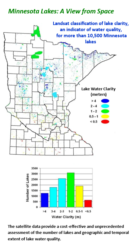
Monitoring and protecting the quality of Minnesota lakes and streams is a major concern for many state and local agencies. However, the expense and time requirements for ground-based monitoring, make it impractical to monitor more than a small fraction of this large resource by conventional field methods. The use of remote sensing is a cost-effective way to gather the information needed for water quality assessments in lake-rich areas.
University of Minnesota researchers have been working since 1996, to research and develop remote sensing-based approaches to monitor water resources. They have been joined by resource managers from local and state agencies. Together they are committed to developing remote sensing as a cost-effective way to acquire information on lakes, streams, and wetlands.
The research and development of satellite-based lake water quality monitoring has been conducted by the Department of Forest Resources – Remote Sensing and Geospatial Analysis Laboratory in collaboration with faculty, staff, and students from several other departments and colleges, the Water Resources Center, U-Spatial, and Minnesota Supercomputing Institute.
Initial efforts were directed at monitoring lake clarity, a key indicator of water quality, with Landsat digital data. More than 10,500 Minnesota lakes were classified nine times from 1975 to 2015. More recently, to take advantage of the increased spectral-radiometric, spatial, and temporal resolutions provided by Landsat 8 and 9 and Sentinel 2 data and advancements in image processing, we developed with the Minnesota Supercomputing Institute, a highly automated, state-of-the-art system to download, process, and analyze satellite imagery for near real-time monitoring of lake clarity, chlorophyll, and CDOM. Utilizing these capabilities, we have created a statewide water quality database with clarity, chlorophyll, and CDOM measurements for 2017 – 2022. The approach is currently being extended to additional areas including Michigan and Wisconsin. We have also conducted research to evaluate the potential of hyperspectral data to evaluate its potential for monitoring water quality, including chlorophyll and sediment, of rivers. Our research methods and results are on the Remote Sensing of Water Resources website, water.rs.umn.edu.
The Minnesota lake monitoring results are available in an ArcServer GIS application known as the Minnesota LakeBrowser, lakes.rs.umn.edu – an online interactive tool available since 2002 with searchable statewide maps of lake clarity, chlorophyll concentrations, and CDOM levels.
Typically, the LakeBrowser is used to obtain clarity and other water quality information for particular Minnesota lakes or surveys at county, ecoregion, or watershed levels. To do so, you can either zoom in and out of areas to locate the lake of interest or search lakes by lake name. Maps of lake clarity, chlorophyll, and CDOM can be displayed by year, and since 2017 by month, along with summaries and statistics at state, county, ecoregion, and watershed levels, as well as land cover maps and statistics for a 1,000-foot buffer area around lakes. The earlier data can be downloaded from the LakeBrowser and more recent data can be accessed through the University of Minnesota GEMS Informatics Exchange. We plan to regularly update the LakeBrowser as resources and new data become available. Links to additional lake information from the Minnesota Department of Natural Resources (DNR) and Pollution Control Agency (PCA) are also available.
Acknowledgments: Our research and development of the LakeBrowser has been supported by the University of Minnesota and state and federal agencies.
- Minnesota Agricultural Experiment Station
- University of Minnesota U-Spatial
- Minnesota Environment and Natural Resources Trust Fund
- Minnesota Department of Natural Resources
- Minnesota Pollution Control Agency
- National Science Foundation
- National Aeronautics and Space Administration
- U.S. Geological Survey
